")
")
")
")

|
|
P A T H S GREEN-AZURE |
|

|
|
FROM SEA TO MOUNTAINS IN THE CARMO'S GROUP WITH THE PATRONAGE OF THE A.P.T. RIVIERA DELLE PALME DI ALASSIO
|

|
USEFUL SUGGESTIONS AND INFORMATION |
| - Always inform someone before making an excursion. For the most difficult courses, supply yourself with heavy boots and wool knee socks because, among the inhabitants of our mountains, there is the viper. | - Since the climatic conditions of our region are particularly propitious, the excursions can be made all the year round. The best periods are springs and autumn. | - The paths condition is generally good enough; yet, because of the particularity of the Mediterranean bush, it can happen to find them temporarily covered by the vegetation in some part. | Symbols: for each path, in order to make its reading easier, the following symbols have been included:
|
|
COURSE N°1 |
Trail sign |
||||
|
BORGHETTO S. S. - SANCTUARY OUR LADY OF "MONTE CROCE DI BALESTRINO" |
|
|
Difficulty: **** |
Km. 7.900 |
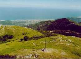
Landmarks: start Via Aurelia Borelli castle or ex primary school - Monte Piccaro m. 281 (graceful little Chapel) - Monte Croce m. 541 (wonderful view on the coast) - Monte sopra Toirano m. 623 - Monte Acuto m. 748 - Sanctuary Our Lady of Monte Croce m. 735. |
| The Sanctuary of Monte Croce was build after the Apparition of the Holy Virgin Mary to a girl of Balestrino. |
|
COURSE N° 2 |
Trail sign |
||
|
TOIRANO - MONTE ACUTO |
|
|
Difficulty: *** |
Km. 3.200 |
Landmarks: start from provincial road Borghetto S. S. - Toirano |
|
COURSE N° 3 |
Trail sign |
||
|
SALTO DEL LUPO - GIOGO DI TOIRANO (Ancient valley road) |
|
|
Difficulty: *** |
Km. 4.800 |
Landmarks: start bridge of Salto del lupo - ancient olive cultivations - suggestive view of the Monte San Pietro crags - fountain/drinking trough - typical cobbled surface - on the left side pinnacles of the Alzabecchi - copses - meadows - Giogo di Toirano |
| Notes: The ancient valley road has been, until the end of 1800, the main thoroughfare of connection between the Riviera and the Bormida upper Valley. People say that: the peaks of the Alzabecchi were the meeting place of the "basure" (witches) for their assemblies, and the name of "Salto del Lupo" (bound of the wolf) derives from the wild solitude of the place which, in times gone by, favored the wolves to attack the travelers. |
|
COURSE N° 4 |
Trail sign |
||
|
BOISSANO - SAN PIETRINO |
|
|
Difficolta': ** |
Km. 2.500 |
Landmarks: start G. Govi square - Receiving tank of the municipal waterworks - cobbled surface - ruins of the ancient San Paul's Church (XIV century) - Casa Molle m. 254 - Casa Fossae m. 321 - Little church of San Pietrino m. 477 |
| Notes: from San Pietrino, turning to the left, you reach Monte St. Pietro in Varatella (see course 5 trail sign otherwise, turning to the right (Napoleonic road) you reach Monte Carmo (trail sign |
|
COURSE N° 5 |
Trail sign |
||||
|
BOISSANO - SAN PIETRO DEI MONTI |
|
|
Difficulty: **** |
Km. 5.000 |
Landmarks: See COURSE 4 , from San Pietrino Trail sign |
| Notes: The solemnity of St. Pietro dei Monti falls on the 1st of May - Religious ceremonies and great rural festival. St. Pietro's Abbey was built at the beginning of 800 d.C. and was given to the Benedictines for will of the Emperor Carlo Magno. People say that: la Pietra del Gallo (cock's stone) was so called, in the popular tradition, because during the night when St. Peter denied Jesus, the cock sang there three times. |
|
COURSE N° 6 |
Trail sign |
||||
|
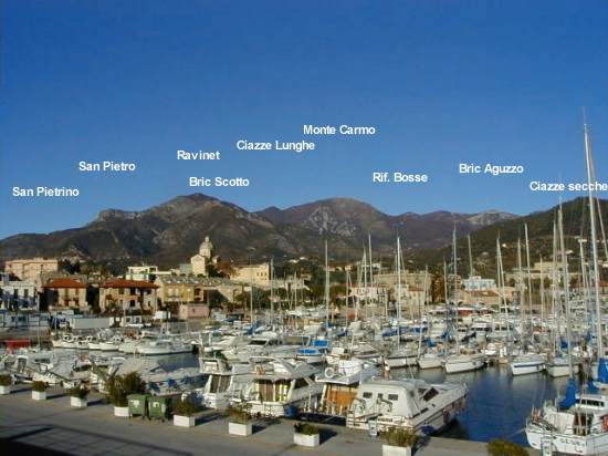
LOANO - VERZI - PIAN DELLE BOSSE - MONTE CARMO |
|
|
Difficulty: **** |
Km. 9.900 |
Landmarks: start Loano - way to Verzi (chargeable) - Parish Church of Verzi (Virgin Mary's statue) - Cascina Corma - Cascina Lanfranco - parking shelter Pian delle Bosse m. 603 - fork Rocca dell'Avio - Shelter CAI m. 841. From this place, to reach the summit of Monte Carmo m. 1389, two paths are practicable: 1st slopes Bric Pratello - Giogo of Giustenice h. 2,00 - 2nd ridge path h. 1,30 continue trail sign |
| Notes: the shelter of Pian delle Bosse (40 beds - possibility of overnight stay and refreshment) built by the CAI Division of Loano is the starting point of interesting excursions and support base for the rock climbing training of the Rocca dell'Avio and of the Butto rock - It's placed in a particularly good region for who loves botany. The "Flower Festival", at Carmo top, falls the first Sunday of June.. People say that: near the Carmo a "bocca da fuoco" (gun) hidden and full of gold, which has been left by the French troops after the Loano battle of 1795. |
|
COURSE N° 7 |
Trail sign |
||
|
LOANO - VERZI - ROCCA DELL'AVIO - MONTE CARMO |
|
|
Difficulty: **** |
Km. 9.800 |
Landmarks: from Loano to the parking of the Pian delle Bosse shelter (see course N° 6) - m. 400 after the parking, fork on the left - Rocca dell'Avio - Costa Sellette - Shelter "Amici del Carmo" ("Friends of the Carmo" - 12 beds - private property) - Carmo top m.1389 |
| Notes: the Rocca dell'Avio, mighty tower of quartzite, is an ideal climbingmtraining (of about m. 90) - Northward rises the Butto rock, an interesting wall for the rock-climbers too. People say that: a great good spirit overhung our lands leaning one foot on the Carmo top and the other on the Giogo of Giustenice, protecting them from the evil spirits.. |